Созопол, Република България

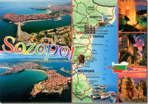
Sozopol (Bulgarian: Созопол) is an ancient seaside town located 35 km south of Burgas on the southern Bulgarian Black Sea Coast. Today it is one of the major seaside resorts in the country, known for the Apollonia art and film festival (which takes place in early September) that is named after one of the town's ancient names.

The busiest times of the year are the summer months, ranging from May to September as tourists from around the world come to enjoy the weather, sandy beaches, history and culture, fusion cuisine (Bulgarian, Greek, Turkish), and atmosphere of the colourful resort. The increasing popularity of the town has led to it being dubbed the Bulgarian St. Tropez, seeing stars like Ralph Fiennes,Brad Pitt, Angelina Jolie and Goldfrapp exploring its beauty and charm.

Part of Burgas Province and administrative centre of the homonymous Sozopol Municipality, as of December 2009, the town has a population of 5,410 inhabitants.

Name

The original name of the city is attested as Antheia (Άνθεια in greek) but was soon renamed to Apollonia (Απολλώνία). At various times, Apollonia was known as Apollonia Pontica (that is, "Apollonia on the Black Sea", the ancient Pontus Euxinus) and Apollonia Magna ("Great Apollonia"). By the first century AD, the name Sozopolis (Greek: Σωζόπολις) began to appear in written records. During the Ottoman rule the town was known as Sizebolu, Sizeboli or Sizebolou.

History

Sozopol is one of the oldest towns on Bulgarian Thrace's Black Sea coast. The first settlement on the site dates back to the Bronze Age. Undersea explorations in the region of the port reveal relics of dwellings, ceramic pottery, stone and bone tools from that era. Many anchors from the second and first millennium BC have been discovered in the town's bay, a proof of active shipping since ancient times.

The current town was founded in the 7th century BC by Greek colonists from Miletus as Antheia. The name was soon changed toApollonia, on account of a temple dedicated to Apollo in the town, containing a famous colossal statue of the god Apollo by Calamis, 30 cubits high, transported later to Rome by Lucullus and placed in the Capitol.

The coins, which begin in the fourth century BC, bear the name Apollonia and the image of Apollo; the imperial coins, which continue to the first half of the third century AD, and the Tabula Peutinger also contain the name Apollonia; but the "Periplus Ponti Euxini", 85, and the Notitiæ episcopatuum have only the new name Sozopolis. In 1328 Cantacuzene (ed. Bonn, I, 326) speaks of it as a large and populous town. The islet on which it stood is now connected with the mainland by a narrow tongue of land. Its inhabitants, in the past mostly Greeks, lived by fishing and agriculture.

The town established itself as a trade and naval centre in the following centuries. It kept strong political and trade relations with the cities of Ancient GreeceMiletus, Athens, Corinth, Heraclea Pontica and the islands Rhodes, Chios, Lesbos, etc. Its trade influence in theThracian territories was based on a treaty with the rulers of the Odrysian kingdom dating from the fifth century BC.

The symbol of the town – the anchor, present on all coins minted by Apollonia since the sixth century BC, is proof of the importance of its maritime trade. The rich town soon became an important cultural centre. At these times it was called Apollonia Magna.

Ruled in turn by the Byzantine, Bulgarian and Ottoman Empires, Sozopol was assigned to the newly independent Bulgaria in the 19th century. At the outbreak of the Greek War of Independence (1821) prominent local personalities were arrested and executed by the Ottoman authorities due to participation in the preparations of the struggle.

Almost all of its Greek population was exchanged with Bulgarians from Eastern Thrace in the aftermath of the Balkan Wars. In 2011 the remainings of an ancient Greek settlement, part of Apollonia, were excavated in the small island of St. Kirik (Saint Cerycus) off Sozopolis.

One of the most active and popular mayors had been Nikola Kaloyanov, who initiated numerous infrastructure changes to modernize the town in the 70s.

Since 1984 Sozopol hosts the Apollonia art festivities every September, which include theatre shows, exhibitions, movies, musical and dance performances, book presentations and other cultural events.

Ecclesiastical history

Sozopol was Christianized early. Bishops are recorded as resident there from at least 431. At least eight bishops are known (Le Quien,Oriens christianus, I, 1181): Athanasius (431), Peter (680), Euthymius (787) and Ignatius (869); Theodosius (1357), Joannicius, who became Patriarch of Constantinople (1524), Philotheus (1564) and Joasaph (1721).

From being suffragan to the archbishopric of Adrianopolis, it became in the fourteenth century a metropolis without suffragan sees; it disappeared perhaps temporarily with the Turkish conquest, but reappeared later; in 1808 it was united to the See of Agathopolis. The titular resided at Agathopolis, in Ottoman days called Akhtébolou, in the vilayet of Adrianopolis (Edirne, in European Turkey).

Eubel (Hierarchia catholica medii ævi, I, 194) mentions four Latin bishops of the fourteenth century.

The city remains a titular see of the Roman Catholic Church, that of Sozopolis in Haemimonto, suffragan of Adrianopolis. The seat has stood vacant since the death of the last titular bishop in 2000.

Art flourished in the Christian era. The ancient icons and magnificent woodcarving in theiconostases are a remarkable accomplishment of the craftsmanship of these times. The architecture of the houses in the old town from the Renaissance period makes it a unique place to visit today.
20

202

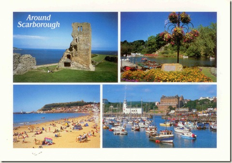
Around Scarborough, North Yorkshire, Yorkshire and the Humber, England

Scarborough Castle is a former medieval Royal fortress situated on a rocky promontory overlooking the North Sea and Scarborough, North Yorkshire, England.The site of the castle, encompassing the Iron Age settlement, Roman signal station, an Anglo-Scandinavian settlement and chapel, the 12th century enclosure castle and 18th century battery, is ascheduled monument of national importance.

Fortifications for a wooden castle were built in the 1130s, but the present stone castle dates from the 1150s. Over the centuries, several other structures were added, with medieval monarchs investing heavily in what was then an important fortress that guarded the Yorkshire coastline, Scarborough's port trade, and the north of England from Scottish or continental invasion. It was fortified and defended during various civil wars, sieges and conflicts, as kings fought with rival barons, faced rebellion and clashed with republican forces, though peace with Scotland and the conclusion of civil and continental wars in the 17th century led to its decline in importance.

Once occupied by garrisons and governors who often menaced the town, the castle has been a ruin since the sieges of the English Civil War, but attracts many visitors to climb the battlements, take in the views and enjoy the accompanying interactive exhibition and special events run by English Heritage.

Features

The 12th-century keep

The castle's location takes advantage of a naturally defensive site on a headland with steep cliffs, 300 feet (91 m) high, on three seaward sides. The promontory is joined to the mainland by an isthmus, where a ditch or moat was cut, and a wall or palisade with a gatehouse built on the southwest landward side. The stone curtain wall dates from the late 12th and early 13th centuries when it was strengthened by the addition of twelve round towers at intervals on its 230 yards (210 m) length. The wall does not surround the inner buildings of the castle. The entrance consists of a barbican, or fortifications to protect the gateway, completed in the 14th century and flanked by two half-circular towers on high ground. Modifications to the barbican have removed evidence of a portcullis and its grooves. The barbican stands in the place of a 12th-century fortification built close to the remains of an 11th-century Anglo-Saxon chapel.

Beyond the main gateway, a stone bridge, built between 1337–1338, to replace two drawbridges, leads to the baileys or courtyards. It leads to the inner bailey, which was used for workshops, offices, a kitchen, and a storage area. Usually a castle's inner bailey is accessed through the outer bailey, however the opposite is the case at Scarborough.

The 86-foot-tall (26 m) 12th-century keep and the castle's 150-foot-deep (46 m) well lie within the inner bailey. The keep, with its entrance on the first floor, survives as a shell, with the west wall, interior floors and roof missing, as a result of bombardment in the 17th-century. With its sloping plinth to aid defence, flat roof and four turrets, this square four-storey building was over 100-foot-tall (30 m). The walls range from 11 to 15 feet (3.4 to 4.6 m) in thickness, the west wall being strongest, and there are several windows, some blocked up along its length. The corners have decorative rounded mouldings. There are the remains of a hearth in the west wall on the first floor, which comprised a single Great Hall, where the occupants ate and often slept. The second and third floors were each divided into two rooms for important visitors or the governor, and the basement was a storage area. Late 20th century resistivity surveys of the inner bailey have traced the outlines of more 12th century buildings.

The baileys are separated by a stone wall, ditch and bank, with two defended gateways. The larger outer bailey would have seen entertaining events staged, vegetables grown, and animals kept; there was a graveyard and St. Mary's Chapel, which has completely disappeared, though the remains of the old Anglo-Saxon chapel on the site of an old Roman signal station can still be seen. A 12th-century medieval building, 100 feet (30 m) in length, stood in the outer bailey to accommodate royal visitors. It consisted of a long hall and private chamber with a fireplace used by the monarch, and rooms for preparing and storing food. The building was demolished sometime before a survey of 1538, which makes no mention of it: only the foundations, excavated in 1888, remain.

In the outer bailey, a building named the "King's Chambers" or Mosdale Hall, after a 14th-century governor responsible for upgrading it, is an example of how the castle has been altered over the years. Originally built in the 13th century and upgraded by Mosdale after 1397, the two-storey building adjoining the curtain wall was converted to red-brick barracks in the 18th century . After being badly damaged by German shelling in 1914, the building was demolished. The red brickwork is clearly visible next to the much earlier outer stone wall, as viewed from Scarborough's South Bay. The 13th-century Queen's Tower, in the wall nearby, also had different uses: initially luxurious accommodation with private latrines, a porch and large windows with bay views were added in 1320. Two of these windows were later blocked up and one was changed to a cupboard with a rubbish chute. The Master Gunner's House, built in 1748, served as accommodation until the early 20th century.

Development as a tourist attraction

During the second half of the 19th century the castle became a tourist attraction. The foundations of a medieval hall were excavated in 1888, and an 1890 photograph shows visitors using the grounds to practice archery. By 1920, the site was taken into public ownership by the Ministry of Works. The demolition of the 18th-century barracks exposed the medieval foundations of Mosdale Hall, which can still be seen.

The castle site, a scheduled ancient monument managed by English Heritage since 1984, is host to various events, usually in summertime, such as pirate and Robin Hood-themed activities. The castle grounds are reputed to be haunted – by three ghosts, among them a Roman soldier. The 18th-century Master Gunner's House, now a museum has an exhibition whose centrepiece is a Bronze Age sword discovered in 1980. English Heritage invested £250,000 in making the site a tourist attraction. A visitor centre provides admission to all extant remains, and has an exhibition of artefacts from the site and viewing platforms.

16

162

Thành phố Nha Trang, Cộng hòa xã hội chủ nghĩa Việt Nam

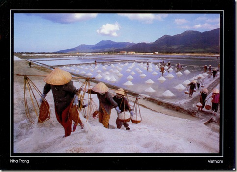
An Ultra Wide view of the incredible Salt Fields in Vietnam. About one hour drive (approx. 45 kilometres I believe) north of the popular beach destination of Nha Trang are the Hon Khoi Salt Fields at Khanh Hoa.

Photo at Hòn Khói salt-farms on National Highway 1 half-way between Nha Trang and Vạn Giả Pass, which is some 30 km North of Nha Trang City where local harvesting salt is the largest salt industry of Khánh Hòa Province. Normally, a liter of salt water collected from this area after evaporation could end up with 35 grams of salt.
Since several centuries ago, salt has been an important and primary role in national revenue. According to Viet Nam History by Trần Trọng Kim, in 1721, King Trịnh Cương created a new department named Giám Dương to collect 20% tax on salt. Buyers must have registered card issued by Giám Dương to be legal for salt purchase. They also have to buy from government officials first prior to dealing with regular producers. Such a tax system triggered high price of salt and effected normal people. In 1732, the king aborted salt system to save his throne from rebels. 14 years later, Trịnh Doanh re-established a method of salt taxing: organizing every 50 acres of salt field into a kitchen (unit); each kitchen must turn in 40 drawers of salt, an equivalence of 180 dongs.
Nowadays, salt still takes its role in Vietnam economy to an extend that we are using satellite photos to help improving salt harvesting. Vietnam has a project of nearly VND134 billion (US$8.4 million) to be invested in industrial salt production to meet domestic demand. The salt industry will invest mainly in developing industrial salt fields in the central provinces of Khánh Hòa, Ninh Thuận and Bình Thuận. Vietnam expects to have about 6,600 hectares of industrial salt fields in its central and southeastern coastal provinces by end of 2005 to ensure a balance in the supply of industrial and cooking salt.
Vietnam produces 300,000 tons of industrial salt annually. Of this amount, less than 200,000 tons are qualified for use in industrial production. As a result, the country still has to import about 150,000 tons of salt for industrial production each year. These imports have brought salt prices down in the domestic market.

13-13

13-14

Варакушка

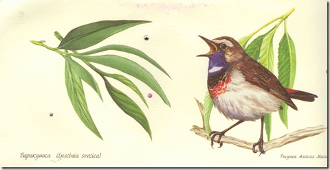
Вара́кушка (лат. Luscinia svecica) — птица семейства мухоловковых отряда воробьинообразных.

Внешний вид

Размером чуть меньше домового воробья. Длина тела — около 15 см. Масса самцов — 15—23 г, самок 13—21 г. Спинка бурая или серовато-бурая, надхвостье рыжее. Горло и зоб — синие с рыжим пятном посередине; пятно может быть белым, или только окружено белым. Синий цвет снизу окаймлён черноватым, а затем рыжими полукольцами поперёк груди. Хвост рыжий с черноватой вершиной, средняя пара перьев хвоста бурые. Самка без синего и рыжего цветов. Горло беловатое, окаймлённое буроватым полукольцом. Клюв чёрный, ноги буро-чёрные.

Ареал

Распространена в Северной Европе, Северной и Центральной Азии; в России — практически на всей территории. Варакушка — перелётная птица. Зимует в Северной Африке, Азии, Южном Китае и Индии.

Места обитания, размножение

Наиболее охотно заселяют речные поймы, долины ручьёв, склоны оврагов, берега озёр, то есть местообитания влажные и заросшие кустарниками. В лесотундре более всего любят редколесья и негустые пойменные леса с ивняками или другими кустарниками. Гнездится на земле. Гнёзда вьют только из травы, иногда снаружи обкладывают мхом. В кладке 4—7 яиц. Окраска яиц — голубовато-серая или оливково-голубая, на тупом конце более тёмная. На многих кладках заметен слабый, более тёмный, иногда чуть красноватый крап. Насиживает только самка. Длительность насиживания в среднем 13 суток. Обе взрослые птицы выкармливают птенцов, которые покидают гнездо 11—13 дней от роду, имея рыжевато-бурую окраску с многочисленными охристыми пестринами. Ещё не умея летать, птенцы неделю докармливаются родителями поблизости от оставленного гнезда.

Миграция

Осенняя миграция начинается в середине августа и заканчивается к середине сентября. Летят варакушки поодиночке, стай не образуют. Птицы независимо друг от друга, но в одном направлении, перелетают от одних зарослей кустарника к другим, стараясь придерживаться речных пойм. Пролёт почти незаметен, так как проходит он не высоко над землёй, а понизу; происходит ночью, за сутки птица преодолевает около 100 километров.

Прилетают в конце мая — начале июня, в одно время с другими насекомоядными птицами. Самцы, прилетающие немного раньше самок, вскоре начинают петь.

Пение

Поющий самец сидит на вершине куста, но иногда взлетает, совершая характерные токовые полёты. Пение продолжается всё светлое время суток, особенно интенсивно самцы поют в утренние часы. Пение звучное, включающее свисты, щебетание и щёлканье, множество заимствованных у других птиц звуков; исполняется в быстрой манере. В песне большинства варакушек есть часто повторяющееся «варак-варак-варак», отчего и происходит название птицы. Латинское название — Luscinia svecica (шведский соловей) — дал в 1758 году шведский учёный  Карл Линней.

Питание

Варакушка — насекомоядная птица. В питании преобладают насекомые и их личинки, обитающие на земле. Осенью значительную долю в питании занимают ягоды.

13-37

13-38

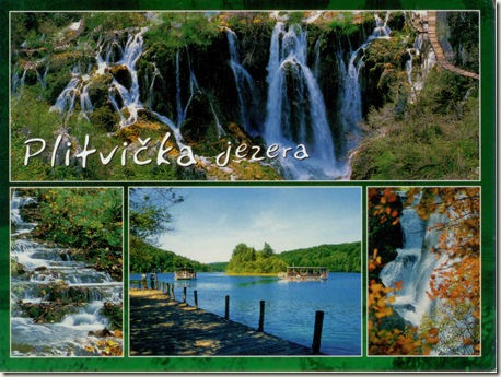
Plitvická jezera, Republika Hrvatska Пли́твицкие озёра

13-33

13-34

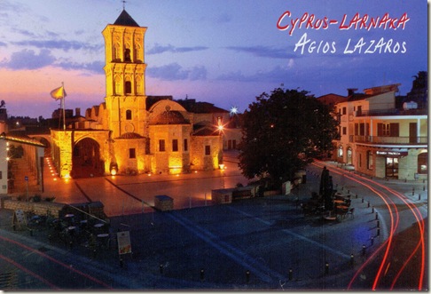
Ιερός Ναός Αγίου Λαζάρου, Κυπριακή Δημοκρατία

The Church of Saint Lazarus (Greek: Ιερός Ναός Αγίου Λαζάρου), is a late-9th century church in Larnaca, Cyprus. It belongs to the Church of Cyprus, an autocephalous Greek Orthodox Church.

The Church of Saint Lazarus is named for New Testament figure Lazarus of Bethany, the subject of a miracle recounted in the Gospel of John, in which Jesus raises him from the dead. According to Orthodox tradition, sometime after theResurrection of Christ, Lazarus was forced to flee Judea because of rumoured plots on his life and came to Cyprus. There he was appointed by Paul and Barnabas as the first Bishop of Kittim (present-day Larnaca). He is said to have lived for thirty more years and on his death was buried there for the second and last time. The Church of Ayios Lazaros was built over the reputed (second) tomb of Lazarus.

(An alternate Western tradition has Lazarus with his sisters Mary and Martha put out to sea in a boat without oars and landing in Provence, France. This alternate tradition puts his tomb at the Autun Cathedral.)

History and architecture

Tradition says that the place of Lazarus' tomb was lost during the period of Arab rule beginning in 649. In 890, a tomb was found in Larnaca bearing the inscription "Lazarus the friend of Christ". Emperor Leo VI of Byzantium had Lazarus' remainstransferred to Constantinople in 898. The transfer was apostrophized by Arethas, Bishop of Caesarea, and is commemorated by the Orthodox Church each year on October 17. The transferred relics were later looted by the Fourth Crusade in the early 13th century and were brought to Marseille but subsequently lost.

In recompense to Larnaca for the translation, Emperor Leo had the Church of St. Lazarus erected over Lazarus' tomb in the late 9th to early 10th centuries. It is one of three Byzantine churches which have survived in Cyprus; the other two are the Church of the Apostle Barnabas near Salamis, and the church that was built in the walkway leading from the Epiphanios to the font.

The church is an elongated building measuring 31.5 x 14.5 m with a tripartite sanctuary, semicircular apses internally and three-sided externally and a five-sided apse in the center. The interior structure of the church is divided into three aisles with bulky double pillars and arched openings going through them. These pillars bear the weight of the domes thus forming the central aisle while the north and south aisles bear a semi-cylindrical roof, intersected by cross-vaults. The stonework of the church consists mainly of square limestone block about a meter in thickness. The church has an open porch, from which steps descend into the church.

Under Frankish and Venetian rule (the 13th to 16th centuries), the church became Roman Catholic. A stone covered portico(stoa) of Gothic style was added on its south side during this time.

The three imposing domes of this Orthodox Basilica Church and the original bell tower were destroyed, probably in the first years of Ottoman rule (1571 AD), when the church was turned into a mosque. In 1589, the Ottomans sold it back to the Orthodox, probably because of its Christian cemetery. For the next two hundred years it was used for both Orthodox and Catholic services. The porch bears traces of Greek, Latin, and French inscriptions. In 1857, after the Ottoman authorities again allowed Cypriot churches to have bell towers, the church's bell-tower was rebuilt in a Latinate style.

The woodcarving of the unique baroque iconostasis of the church was done between 1773 and 1782 by Chatzisavvas Taliadorou. The iconostasis was gold-plated between 1793 and 1797. Some of the icons were painted towards the end of the 18th century by Michael Proskynetes from Marathasa. Icon painter Hatzimichael completed the iconography of the iconostasis in 1797. Some of the wood-carved furniture (including a Rococo pulpit on one pillar for Catholic use) and icons on the walls are from the 17th century.

A fire in 1970 damaged much of the interior, including extensive damage to a section of the iconostasis together with the corresponding icons. The iconostasis has been partially restored and was re-plated with gold between 1972 and 1974. During the subsequent renovations of the church, on November 2, 1972, human remains were discovered in a marble sarcophagus under the altar, and were identified as part of the saint's relics (not all having been removed to Constantinople, apparently).

Traditions

On Lazarus Saturday, eight days before Easter, the icon of Saint Lazarus is taken in procession through the streets of Larnaca.

13-3

13-32

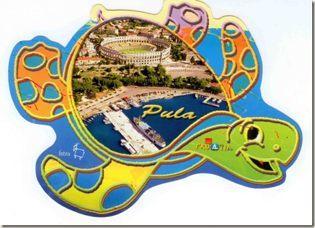
Pula, Republika Hrvatska

13-35 13-36

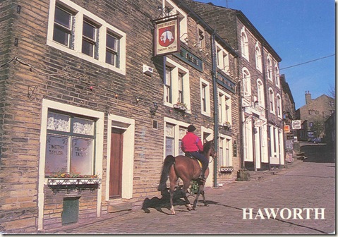
Haworth, City of Bradford, West Yorkshire, England

Haworth is a rural village in the City of Bradford metropolitan borough of West Yorkshire, England. It is located amongst thePennines, 3 miles (4.8 km) southwest of Keighley and 10 miles (16 km) west of Bradford. The surrounding areas include Oakworthand Oxenhope. Nearby villages include Cross Roads, Stanbury and Lumbfoot.

Haworth is a tourist attraction, best known for its association with the Brontë sisters.

History

Haworth is first mentioned as a settlement in 1209. The name may refer to a "hedged enclosure" or "hawthorn enclosure". The name was recorded as "Howorth" on a 1771 map.

Governance

Haworth village is part of the parish of Haworth, Cross Roads and Stanbury, which in turn is part of the Bradford Metropolitan District Council, one of the five metropolitan boroughs of  West Yorkshire.

Geography

Haworth is situated above the Worth Valley amid the Pennine moors. It is 212 miles (341 km) north of London, 43 miles (69 km) west of York and 9 miles (14 km) west of Bradford.

Economy

Tourism accounts for much of the local seasonal trade, with the major attractions being the steam railway and the Brontë parsonage. In Haworth there are tea rooms, souvenir and antiquarian bookshops, restaurants, pubs and hotels including the Black Bull, where Branwell Brontë's decline into alcoholism and opium addiction allegedly began. Haworth is a base for exploring Brontë Country, while still being close to the major cities of Bradford and Leeds.

On 22 November 2002 Haworth was granted Fairtrade Village status. On 21 October 2005 Haworth Fairtrade officially signed an agreement to twin with Machu Picchu in Peru.

The car-clamping firm Carstoppers, who patrol the Changegate car park ihas been accused of driving away tourists and was given the 'Dick Turpin' award by the RAC, for being a modern day highway robber.

Culture

Haworth's only traditional events were an annual service at Haworth Spa and the rush bearing. Spa Sunday died out in the early 20th century and the rush bearing ceremony has not been held for many years. A modern event organised by the Haworth Traders' Association is "Scroggling the Holly" which takes place in November. Bands and Morris men lead a procession of children in Victorian costume following the Holly Queen up the cobblestones to a crowning ceremony on the church steps. She unlocks the church gates to invite the spirit of Christmas into Haworth. Father Christmas arrives bringing glad tidings.

The first Haworth Arts Festival took place in 2000 and was repeated in 2001, but then ceased. It was revived in 2005 as a festival combining performing arts, visual arts and street performance. The festival has strong community involvement using local professional and semi-professional musicians, artists and performers and a larger name to headline each year, providing a stage for the likes of John Cooper Clarke and John Shuttleworth. The festival continues to expand across the Worth Valley outside of Haworth and is held on the first weekend in September, starting on Thursday and running until Sunday night.

The Haworth Band is one of the oldest secular musical organisations in the Keighley area. History records indicate that there was a brass band at Ponden, close by in 1854 with a body of excellent performers. It was founded by John Heaton who lived at Ponden. The band had played at a celebration in Haworth at the conclusion of the Crimean War. Over the years the world of brass band music went from strength to strength, during which time the Haworth Band went with it. As it stands today the Haworth Band is a busy and thriving organisation that is closely linked to the local community.

Every year the village hosts a 1940s weekend where locals and visitors don wartime attire for a host of nostalgic events.

Notable people

Brontë sisters

The Brontë sisters were born in Thornton near Bradford, but wrote most of their novels while living at the Haworth Parsonage which is now a museum owned and maintained by the Brontë Society, when their father was the parson at the Church of St. Michael and All Angels. In the 19th century, the town and surrounding settlements were largely industrialized, which put it at odds with the popular portrayal in Wuthering Heights, which only bore resemblance to the upper moorland that Emily Brontë was accustomed to.

Filmography

Haworth and Haworth railway station have been used as settings for numerous period films and TV series, including The Railway Children (starring Jenny Agutter), Yanks (starringRichard Gere and Vanessa Redgrave), and Alan Parker's film version of Pink Floyd's The Wall (starring Bob Geldof). It also featured in "Wild Child" (starring Emma Roberts), and "The Souk" (a high class vintage shop) was depicted as a charity shop.

13-1

13-12

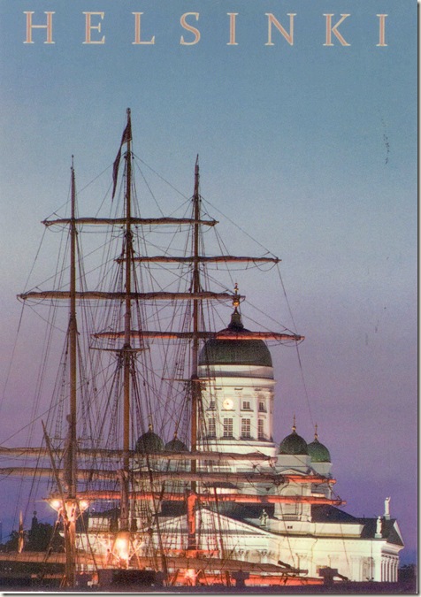
Eteläsatama, Helsinki, Suomen tasavalta

South Harbour (Finnish: Eteläsatama, Swedish: Södra hamnen) is a bay and harbour area immediately next to the centre of the city of Helsinki, Finland. It is the largest passenger harbour in Finland, and 5.4 million passengers travel through it every year. The most of the harbour's traffic is to Stockholm, Sweden and Tallinn, Estonia, and cruises. In summertime, there is also much small ship traffic.

The bay is bordered by the districts of Katajanokka, Kaartinkaupunki, Ullanlinna and Kaivopuisto. The waterway leading to the South Harbour is 9.6 metres deep. The most critical point on the waterway is the Kustaanmiekkastrait, with a width of 80 metres. The waterway has a speed limit of 30 km/h, except for the Katajanokka area, which has a speed limit of 10 km/h.

Piers and terminals

The South Harbour has eight named piers and four terminals.

The Katajanokka Quay (Finnish: Katajanokanlaituri, Swedish: Skatuddskajen) runs nearly the whole length ofKatajanokka, with a length of 740 metres and water depth of 8.8 metres. The furthest part of the pier, towards the sea, consists of the cruising ship pier, with a water depth of 10.3 metres. At the middle of the pier is the Katajanokka Terminal, used by the Viking Line cruiseferries among others. At the end near the Helsinki Market Square is the Kanava Terminal (Finnish: Kanavaterminaali, Swedish:Kanalterminalen), used by express ships travelling to Tallinn. The terminal is named after the Katajanokka channel.

In front of the Presidential Palace is the Linnanallas (Slottsbassängen) bay, used by visiting small boats. Between the bay and the sea lies Linnanlaituri (Slottskajen), used for traffic to Korkeasaari and Porvoo.

At the Market Square shore is Keisarinluodonlaituri (Kejsargrundskajen), named after an islet that the ship carrying emperor Nicholas I of Russia collided with in 1833. Nowadays the islet lies under filling ground brought to the shore. The pier is used mostly by the commuter ship to Suomenlinna.

On the other side of the disused turning railway bridge is the Cholera basin, named after a seaman who died from cholera. The bay is used by fishermen and tourist ships.

Next to the old market hall is the Vironallas (Estbassängen) bay, used by visiting boats. The part between Vironallas and the former railway bridge is called Lyypekinlaituri. It was formerly used by ships to Lübeck, Germany. The pier between Vironallas and the sea is called Pakkahuoneenlaituri (Packhuskajen). It is 135 metres long and has a water depth of 6.0 metres.

Next is the Makasiini Terminal (Finnish: Makasiiniterminaali, Swedish: Magasinterminalen), used by express ships to Tallinn. The Makasiini Quay pier next ot is 270 metres long and has a water depth of 7.2 to 7.5 metres. At its end is the Matkustajalaituri (Passagerkajen) pier, used by loading cruiseliners to Stockholm.

The southernmost terminal is the Olympia Terminal, built for the 1952 Summer Olympics. It is used by the cruiseferries of Silja Line. The Olympia Quay pier next to it is 370 metres long and has a water depth of 7.5 to 8.8 metres.

On the Valkosaari island in front of the Olympia Terminal is the home port of Nyländska jaktklubben (NJK), Helsinki's oldest yacht club, and a restaurant. In summertime, there is a regular ship connection to the island from the south side of the terminal.

History

In the 17th century, the bay was called Kaupunginlahti (Stadsviken). Its shores were so low that it was only suited for a harbour for boats owned by the inhabitants of the coast and the islands. In the 18th century, the main loading point on the bay's shore was the Erhardt pier. In the middle 18th century, the bay was called Eteläinen kaupunginsatama (Södra Stadshamnen). For long, it was a secondary harbour. As traffic increased, fastening places for ships were built on the shores and harbour warehouses for storing cargo were built.

When Helsinki was made the capital of Finland, the bay's shores were filled and they were first outfitted with wooden piers, later by stone piers. The city wanted to turn its secondary harbour into a first-class one. In the early 19th century, the Market Square was founded on filled ground. A minor incident happened in 1827, when the bottom of the filled ground failed, and masses of land flowed down to the sea. The Makasiinilaituri pier also sank to the sea. Further harm to harbour visitor was caused by the shipwrecks, which could lie on the bottom of the sea for years.

For long, the Ullanlinna shipyard was located at the southern part of the bay, which was renamed to Ulricaborgs skeppsvarf (Finnish: Ullanlinnan Varviyhtiö) in 1847. In Katajanokka, shores were being filled and built with piers and handsome cargo warehouses. The connections to the harbour improved considerably, when a railway was built there from 1891 to 1894. In 1900, a new customs house was built in Katajanokka. In the same year, the harbour was being excavated and the Eteläranta side was completed. Thus Eteläsatama got its current form.

In 1922, Helsinki got the icebreaker Hercules, so that ships could also travel in winter. For transport of heavy cargo, the harbour got a 25-tonne crane in 1894. More cranes were acquired starting from the 1920s, so that in 1939, Eteläsatama already had 14 cranes.

In 1936, the city council decided to expand Eteläsatama to the Helsinki shipyard. This included extensive track work to the railways, which were completed in 1952. In the same year, a pier in Katajanokka collapsed into the sea, and part of the long pier had to be closed. The car ferry era between Finland and Sweden began in the early 1960s. Cargo traffic in Katajanokka was discontinued and the railway there was dismantled in the early 1980s. Since that time, Eteläsatama has been used by passenger ships and car ferries.

27

272

Mieliausi sveikinimai!

273

274